Daveed, our guide, took us to several Inca sites in the Sacred Valley, including Pisac, Moray, and Ollantaytambo. We also went to visit the pre-Inca salt ponds at Maras.
Urubamba, which is the name of the river and one of the Inca towns by the river, actually means “sacred valley”. The Urubamba stretches from east to west all the way to the Amazon, following the path of the sun, which makes it very fertile. Apparently, the east-west orientation also matches the path of the Milky Way in the night sky during a certain part of the year, and so the valley has a special relationship with the heavens in the Inca traditions.
Pisac
The ruins near the town of Urubamba, known as Pisac, have the shape of the condor. In the panoramic photo below, you can see the two “wings” of terraces sweeping up the hillside.
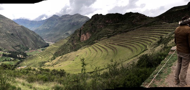
Our guide, Daveed, called our attention to a large number of cavities in the hillside behind the ruins - about 20,000 of them. He said that archeologists found numerous human skeletons in each hole. They believe that this was the burial grounds for all the dead common people from the valley (the kings and important folks were mummified elsewhere). There are no burial grounds, for example, at Machu Picchu. So the idea is that when someone died, there was a six-day procession from Machu Picchu to the burial grounds at Pisac, where the Condor could carry them across the river and up into the spirit world.
Moray
Daveed and our driver, Jose, decided to give us a special treat and take us up a back road to see Moray. This was quite an experience. We turned off the main road to cross the river on a one lane bridge with a gate and guard. I think his job was to make sure idiots who didn’t know what they were doing didn’t go across -- there were times when David and I wondered what we had gotten ourselves in for. After crossing the river, we had to cross some railroad tracks but the car bottomed out and we had to get out. David gave the car a push to get it over the rails.

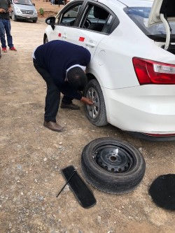
In that photo, note the blue hubcap on the rear wheel. That becomes significant later.
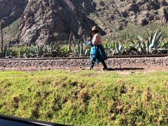
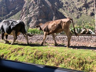
We drove along the tracks for a bit and passed a woman herding a couple of cows, which she moved to the other side of the tracks to let us by.
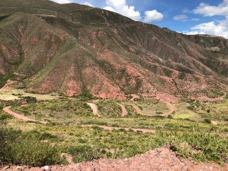
In a while, the road headed uphill and became a combination of bumpy gravel and mud (it had rained the night before). We gradually ascended into the Andean highlands with switchback after switchback, a few of which you can see in the photo below.
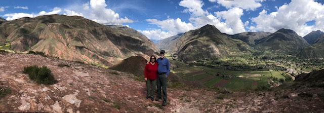
Eventually, we stopped at a viewpoint for photos with the Urubamba in the background.
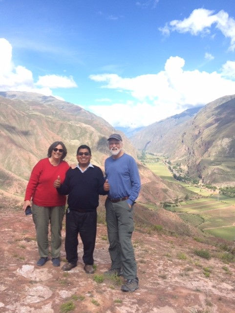
Our driver wanted a photo with us too.
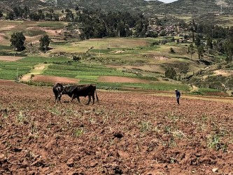
Once we were in the highlands, we realized that it is a different world up there with farms and villages wherever they could perch. We were constantly amazed at how far up the mountains these people cultivate crops. We were at an elevation of about 12,000ft and the fields kept going above us.

Finally, we arrived at the beautiful circular terraces of Moray.

Apparently, there was a lake here that drained away leaving the depression that the Incas took advantage of, creating an agricultural laboratory. Daveed told us that studies have determined that the temperature varies by several degrees at each level and soil was brought from other parts of the empire so the Inca agronomists could experiment with different growing conditions for various crops. They seem to have used hybridization to develop edible crops from wild plants, including over a thousand varieties of potato. The thought is that seeds and roots from this site were distributed throughout the Inca empire to promote agriculture. Amazing people!
Maras Salt Ponds
From Moray, we crossed a high plateau of more fields to the amazing salt ponds of Maras. Here there is a natural underground spring of salt water with a number of beneficial elements in it including calcium, magnesium, and iron. It seems to be a mystery exactly where this salt water comes from at such a high altitude but it has been flowing since pre-Inca times.

This tiny trickle of a spring feeds a huge network of shallow ponds constructed over the centuries to evaporate the water and harvest the salt.
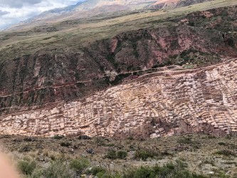
The ponds gradually descend in elevation so that one pond feeds another, feeds another, feeds another, presenting a gorgeous geometry of salt encrusted walls and shiny reflections.
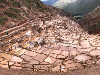
The ponds are worked by families in the community on an informal but organized basis. The community also charges a fee for tourists to visit the site and families have stalls selling water, snacks and their arts and crafts.
So, after marveling at the ingenuity and industry of these people, we returned to the parking lot to find out that our car had a flat tire and the driver was looking for a spare tire. Remember the blue hubcap I pointed out earlier - well, apparently that was the spare tire that was already in use. After about a 15 minute wait, Jose finally found another driver willing to loan him a spare tire and he went to work to change it. This eventually turned into a communal enterprise as other drivers came around to offer advice and assistance. The drivers of the tour buses seem to have their own society.
Ollantaytambo
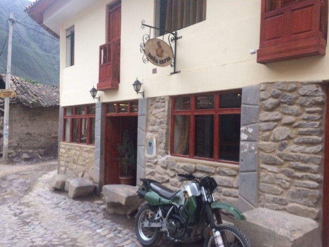
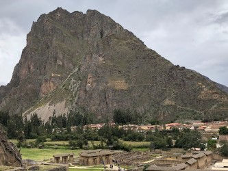
Ollantaytambo is an adorable little town where we stayed for several nights while we explored the various sites in the Sacred Valley. It is at the end of the roadway towards Machu Picchu -- from there you have to take the train to Aguas Calientes. So most people either stay in Cusco and take the train all the way to Aguas Calientes and back, or spend the night in Aguas Calientes before going up to Machu Picchu. We were really glad that we stayed in Ollantaytambo, a little off the worst of the beaten tourist track. We stayed at the Dona Catta Inn with friendly staff, had a breakfast each morning of scrambled eggs, fruit and bread, and enjoyed some very good restaurants.
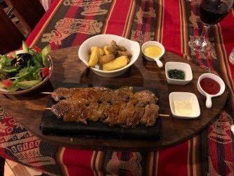
Unfortunately, we didn’t take many photos of the village streets, most of which were for pedestrians only, or the central plaza where old folks, children, chickens, and dogs hung out, or the market where we bravely purchased some fruit from a wizened little lady. So sorry about that. However, here are photos of David’s alpaca dinner and my cream of pumpkin soup where we at the first night. We were also serenaded by a Quechuan musician playing guitar and pan pipes, which he had on a holder around his neck the way Bob Dylan would have his harmonica. The food and the music where excellent.

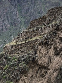
Ollantaytambo is also the site of more Inca ruins, this time in the shape of a llama, although we couldn’t tell that from our vantage point. There were two series of terraces which were supposed to be the legs and then a complex of passages and buildings above them.
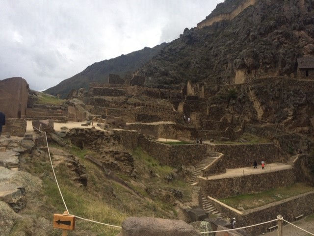
Also, as all Inca ruins seem to have, there was an astrological component. This time a face carved into the side of the mountain on the left below - but you won’t be able to see it very well - combined with the niches in the rock wall over on the right, which is from one side of the valley to the other. Apparently, when the sun is approaching, I believe it is the summer solstice, one of those important days anyway, it shines through the eye of the face on the mountain into one of those niches, gradually moving across until it hits the last niche on the appointed day. I think this marked the beginning of the planting season. Unbelievable!
Another part of the ruins on the ground level was a complex of fountains and streams and a building described as the Water Temple.

During our excursions around the Sacred Valley, we saw numerous colorful markets where all sorts of beautiful weaving and artwork and as well as cheap tourist trinkets were sold.
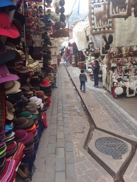
If we had had any room in our luggage, I would have loaded up. I did buy some beautiful silver earrings though.
Next, we returned to Cusco for a last day tour with Daveed.
Comments